TWO HIKES, 50KM, THREE DAYS
10-13 January. The drive into the park meandered gently for nearly 20 kilometres before reaching the visitors’ centre. The road wound through open grasslands, following rivers and backed by serrated mountains still holding pockets of late snow. Guanaco roamed and grazed — some lifting their heads as we passed, most running from the sound of vehicles. Everything was golden-beige brown, the same colour as the puma we were hoping to see.


RANGERS RECOMMENDATONS
The Welcome Centre felt more like an estate than a rustic ranger station — a cluster of grand, stone-clad buildings that were once part of a sheep station. Manicured lawns rolled outward, gravel paths curved between thoughtfully planted native gardens, and the whole place carried the quiet elegance of a grand estancia, as they say down here.
Nearby, on a small rise overlooking the Chacabuco Valley, lies the grave of Doug Tompkins — a fitting resting place in the landscape he worked so fiercely to protect. His vision was to restore vast tracts of Patagonia and return them to public hands, and he did exactly that.
Inside the ranger station we gathered maps and advice, spreading them across the counter while a ranger helped us shape a plan. Two hikes: an 18km day loop through the Avilés Valley, and a 32km overnight following the Río Chacabuco downstream.
Since camping isn’t allowed in the park, except in designated sites for an extortionate fee of $50. Not wanting to drive all the way out and then return the next morning, we opted to pay and booked a campsite — “splashing out” to stay inside the park boundaries, lured by the promise of a hot shower, but…
It wasn’t hot.
Not even close.


THE AVILÉS VALLEY LOOP 18KM
We set off the next morning around 11am, crossing the wide valley floor toward the Avilés trailhead. The path climbed gradually through alpine pastures where wildflowers grew — delicate in appearance yet small and hardy, pushing bravely through wind-hardened soil. The mountains rose around us in layers: soft greens below, grey scree and ochre rock above.
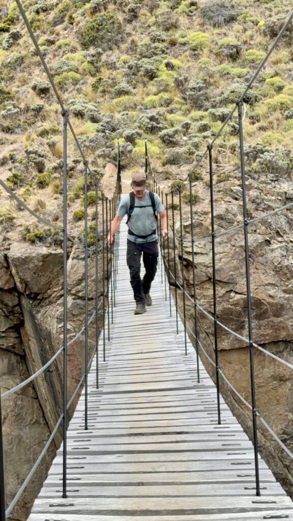
Eight kilometres in — the halfway point — we reached a narrow wooden swing bridge, one person at a time. Ropes on either side offered some stability, though I was surprised by how much it moved. It may have only spanned 50 feet, but it hung high above a narrow channel where water surged rapidly through. Slightly nauseating.
We lunched on the far side.


From there it was up one side and down the other. Not entirely downhill — first a climb onto a long, flat bench where Austral parakeets darted and squawked in the trees. Then the descent began in earnest.
Five hours after leaving, we crossed the dry riverbed near camp just as Andean condors lifted overhead. Jaxon had the binoculars out, confidently identifying a male and female pair circling high above the valley.
Walking back into camp dusty and tired, we found Huw and Sara had just arrived in Gwenda. Soon after, the Dutch family rolled in with their truck, Leo. That night we camped together — and, being slightly cheeky, didn’t pay for a second stay.
At 8am the next morning, rangers made their rounds asking neighbouring vehicles for proof of payment — except us. How we escaped unnoticed remains a mystery. It’s not like Bruce can hide behind a shrub. Perhaps they recognised us from the night before… and our cold showers.
RIO CHACABUCO SENDERO – 30KM
We relocated a few kilometres downstream, parked Bruce, locked up, and loaded our packs. Around 11am we set off again. The kilometre markers began at 30, so technically we were walking it backwards.
The concept was beautifully simple: follow the river 30 kilometres downstream, keeping an eye out for white trail markers. A new trail system, complete with huts — and free of charge. Exactly the kind of thing we wish existed back in Canada.
The valley was gentle rather than dramatic — wide river flats, rolling grasslands, distant peaks and quiet. We crossed several side rivers without bridges, Tim and Jaxon plotting rock-hopping routes to keep boots dry. One crossing proved too wide — boots off, icy ankle-deep water, slippery stones. Actually, it felt good to cool our feet. We sat on sun-warmed rocks and dried them.


We didn’t get lost — but we did lose the trail markers.
Armed with map and compass, the kids took control. Watching them debate bearings, confirm landmarks, agree and disagree — it was brilliant. They eventually found a marker but weren’t convinced it was correct as there was no visible path. After retracing our steps — briefly ending up near someone’s horse property — Jaxon insisted it had to be right. We bushwhacked forward until the trail finally revealed itself. One of those odd moments where the marker says “yes,” but nothing else does.
By 16 kilometres the weight of our packs began to speak. Over the next few kilometres Jaxon’s feet and calves started to seize. At 20 kilometres we reached the second hut — Jaxon hobbling in, muscles knotted and protesting.
No mercy from Tim, who promptly sent both kids down to the river to filter water.
It’s good for them to carry their own packs and equipment, lots of learning and growing happening.
The hut was simple but thoughtfully built: wide wooden benches large enough for sleeping, a sturdy central table, solid walls against the wind and windows on three sides for light. About 50 metres away stood a pristine new outhouse. The previous occupants had left the windows open, so we swept and cleaned a little before getting settled in.
It was fun. We cooked dinner, played Monopoly Deal in fading daylight, and crawled into sleeping bags as the sky finally darkened close to 10pm.
Full bellies.
No other humans for miles.
Just us, the river, and wind beyond the walls.


A BRIDGE NOT FAR
We slept deeply. Tim woke first and announced we’d “slept in” until 8am. Through the windows we could see rain clouds building.
With only 10 kilometres remaining, we guessed we’d be back at the visitors’ centre by 11am. Packs lighter, and legs feeling much better with a dose of ibuprofen we were feeling good. Perfect hiking temperature — no bugs, no rain.
Still no puma, though we found scat and prints along the trail — proof they were here.
The final bridge grew larger in the distance — higher and longer than the others. The wind howled as we crossed two at a time, the whole structure swinging unnervingly.
Once across, the last two kilometres stretched through tall grass plains where guanaco grazed in loose herds, skittish and alert. We scanned every ridgeline.
Still no puma.


DOUG TOMPKINS VISION
Around 11:30am we were back at the visitors centre. While Tim hitched a ride up-valley to get the truck. Charley, Jaxon & I went into the museum.
Beautifully curated — less a display of facts and more a journey through time. It tells the story of this valley: once heavily ranched and overgrazed, fences dividing land where wildlife once moved freely. It walks us through the restoration process — removing fencing, reintroducing native species, allowing ecosystems to heal. At its heart is the vision of Doug Tompkins — that conservation at scale is possible, and that wild places can be returned not just protected, but restored.


Out front, we crossed paths once more with Sara and Huw before parting ways again, certain our tracks will intersect further down the road.
Still no puma.
But Patagonia had given us something else entirely.
One Response
How fantastic! I remain jealous!